
Ecological Verification
SARE Producer Grant
Project Title: Sub-soiling: An Affordable and Effective Water & Soil Conservation Strategy
Mandy applied for this SARE grant in 2017 with the hope that it will turn into a long-term monitoring project for our ranch. Below is a summary of our proposal that was submitted to SARE. Mandy was awarded the research grant in 2018. We will share the results with all of you in 2020. We are establishing “base line” data points that we hope to continue monitoring long-term. A special “thank you” goes to SARE (Sustainable Agriculture Research & Education) and our collaborators at Texas A&M AgriLife Extension Service.
Statement of Problem:
Starting a sustainable agriculture business comes with an abundance of challenges. When record drought is added to that equation, success seems impossible and is enough for even the most seasoned producer to call it quits. For many, “sustainability” is thrown out of the window and their focus shifts to survival. As young producers, the most recent drought (2011-2014) made us realize that water will be the greatest conservation concern we will experience in our lifetime.
Near the beginning of the drought we owned 80 cows and produced around 1,000 laying hens and 5,000 broilers annually. We were leasing approximately 1,200 acres for cattle and raised the poultry on approximately 100 acres. Throughout the drought period, we reduced our cow/calf herd size by 75%, fed hay, rotated our pasture-raised poultry shelters daily, and reduced poultry numbers, but our efforts were not enough. The result was financial loss, disappointment, and scorched earth void of plants, animals, nutrients, and moisture. When the rains returned, we watched as it ran off our desertified hills dreaming of ways to slow, stop, and spread the water on our landscape.
The devastation was wide-spread and many producers across the county, state, and entire southwest experienced the worst drought since the 1950’s. Reference Figure 1.

Figure 1. US Drought Monitor depicts “exceptional” drought for majority of Texas and other Southwest states in September 2011.
So many questions were on our mind during drought recovery. How could we ever have a productive and profitable agriculture business that maintained and benefited overall ecosystem function when we had such limited rainfall? How could we persist in a sustainable fashion until the rains came again? Most importantly, how could we best prepare our land and business for the inevitable droughts of the future?
Statement of Proposed Solution:
Consumed with the challenge of drought, we read literature, looked at photographs, and watched documentaries that demonstrated a diversity of water capture techniques, especially in arid environments. One approach to the solution came from reading P.A. Yeoman’s “Water for Every Farm” and studying the concept of keyline design. Additionally, observing water capture practices implemented by farmer and author Mark Shepard helped us see that sub-soiling would likely be an affordable and effective tool for our landscape.
In March 2013 we purchased a single shank sub-soiler (Bison SVH-1) and began sub-soiling a Kleingrass pasture that had been devastated by drought. The pasture was 100% bare ground in many areas, organic matter was extremely limited, and the hard pan topsoil would not allow water to infiltrate. The tool made 24” deep slices in the earth approximately 10’ apart on contour with the land. We waited. Months pased and we received 6” of rain. The results were incredible (Figure 2). When rains came the water no longer ran off our fields but soaked down deep into the soil. Grass grew in perfect lines on contour, exactly where the plow had cut.
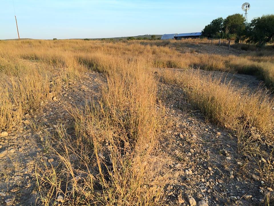
Figure 2. Sub-soiled Kleingrass pasture in March 2013 and again in November 2013.
We conducted vegetation surveys in March 2014, 2015 and 2016. Results were very positive, most notably the reduction in bare ground and increase in forbs and litter (Figure 3).

Figure 3. Vegetation survey results on sub-soiled Kleingrass pasture between 2014-2016.
Based on our experiences, we propose that subsoiling is an effective, low cost, and easy to implement tool for water and soil conservation. We believe it can be adopted widely to help producers 1) reduce runoff, 2) increase water infiltration and soil moisture, 3) aerate soils, 4) build soil organic matter, nutrients, and microbial life, 5) reduce compaction, and 6) ultimately improve forage production.
A Southern SARE Producer Grant would allow us to implement sub-soiling across two pastures and design a survey to measure the effectiveness of this technique on a variety of soil types, plant communities, and pasture conditions. We feel confident that the proposed project aligns with the Producer Grant Review Committees’ Focus Area of “Increasing Sustainability of Existing Farming Practices - Any practice or system that increases the sustainability of an existing farming practice. The results should be able to be used by other farmers”.
Over a two-year period, two pastures will be surveyed to create a side-by-side comparison of sub-soiling’s effect on a variety of soil types, pasture conditions and vegetation types. These pastures have never been sub-soiled, have not received fertilizers in the past eight years, and are all grazed by livestock. Reference Table 1.
Pasture One Native Prairie
Soil Type Divot Clay Loam
Acres 50
Notes Cultivated/fertilized heavily for 100 plus years. Planted in native grass/forbs 5 years ago.
Pasture One Bermuda Pasture
Soil Type Atco Loam, Castroville Clay Loam, Divot Clay Loam
Acres 15
Notes Brush Cleared and planted 30 years ago.
Control sites (not sub-soiled) and treatment sites (sub-soiled) will be established in each pasture. Sub-soiling will take place in August of 2018 and 2019. This timing was chosen because it is typically dry and many perennial plants are dormant, the majority of fawning and grassland bird nesting is complete, and it will be prior to presumable September rains. The sub-soiling tool will be pulled with a tractor along the land’s contour lines every 10 feet and digs 24 inches deep and between 4-8 inches wide.
Approach and Methods:
Survey methods to determine effectiveness of sub-soiling are described below. Reference timeline.
1. Spatial Reconnaissance of Pastures
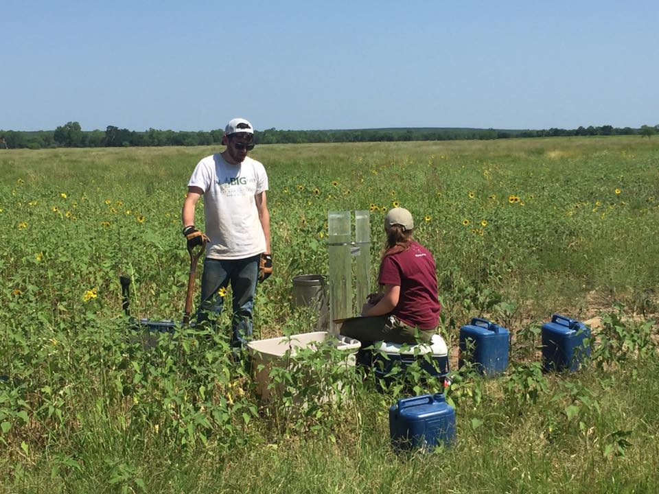
Both pastures will be surveyed using a non-invasive electromagnetic induction instrument prior to sub soiling and any sample measurement (Neely et al., 2016; Watson et al., 2017). This instrument will create a high spatial resolution (5-m) map of how the soil varies to 1.2 m deep. The map will be used to inform the experimental design of how to split each pasture into the treatment and control. The information will create a stronger experimental design as we will be assured that the control and treatment are performed on similar soil variability. The collaborator, Dr. Morgan will provide a student and the EMI instrument to perform the survey. The survey will take 4 hours and consume 1 4V battery (i.e. costs are minimal).
2. Vegetation Cover Survey
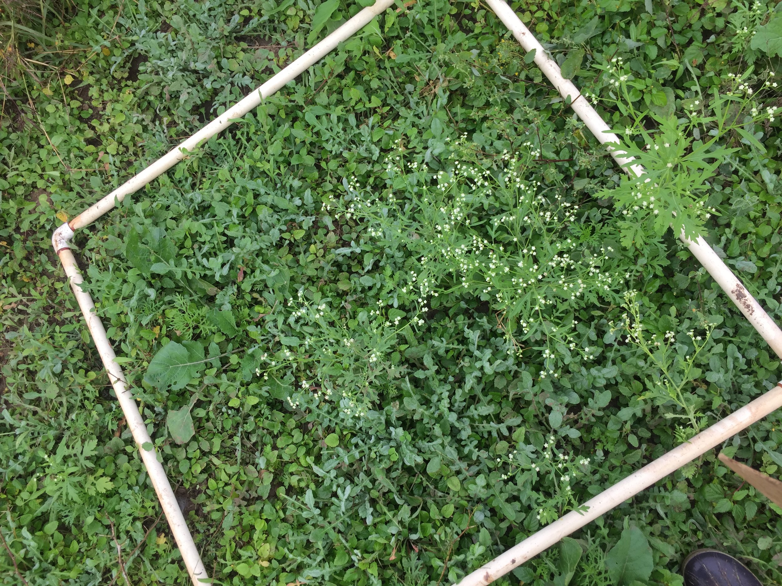
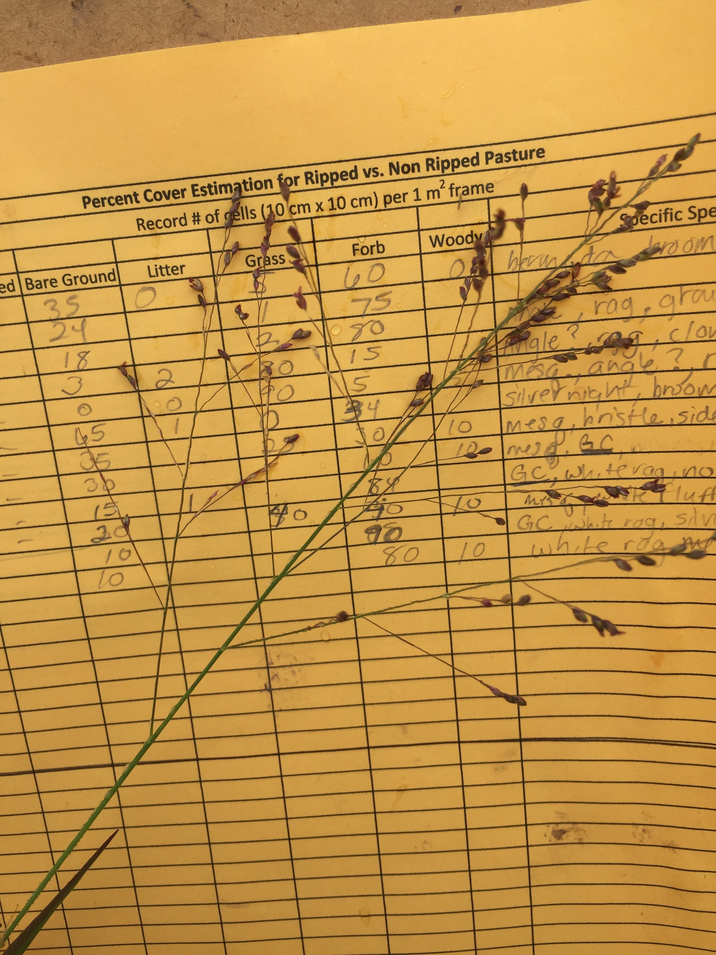
We will conduct vegetation cover surveys to determine relative abundance and presence of plant species in both the control and treatment pasture. Using a m2 quadrat along 50 m transects, we will estimate percent cover of bare ground, litter, grass, forbs, and woody species at 0m, 19.5m, and 39.5m intervals.
3. Soil Nutrient
Soil samples will be collected prior to sub soiling for baseline nutrient analysis and repeated at the end of the study. Data will be sued to inform our nutrient management plan and vegetation production goals.
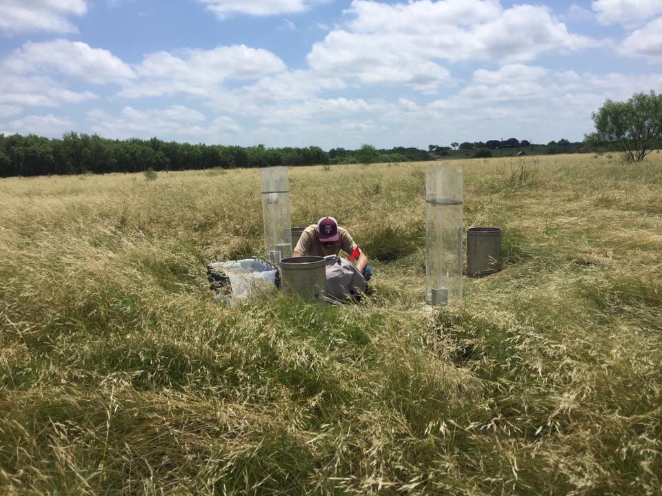
4. Soil Compaction:
Soil Compaction will be measured in both control and treatment sites. Initial measurement locations will be georeferenced so the same places are returned to for the second measurement. Measurements will be made with a soil penetrometer that has a visible and near infrared spectrometer mounted to it (Ackerson et al., 2017). Location soil cores will be pulled and soil texture, water content, inorganic carbon content, and bulk density will be measured at 15 depth increments. The VisNIR mounted penetrometer is an experimental device that is proven to measure soil properties of clay content, calcium carbonate equivalent, bulk density, and water content. Experimentation of this devise is funded by the USDA AFRI Foundational program of which Cooperator Morgan is a co-PI. Morgan will perform the measurements and subsequent laboratory tests. Compaction results along with soil characterization will be shared fully with the Krauses for outreach and any other uses.
5. Infiltration Test:
Hydraulic conductivity of the soil surface will be measured using the single ring constant head method. Infiltration will be measured before the deep soil ripping and approximately one year after. Tests will be timed to capture infiltration rates when the soil is at field capacity. Measurements will be performed by PI, Krause, using an infiltration trailer that is owned by the USDA NRCS Teas Soil Survey and maintained by collaborator, Morgan. Morgan will provide training on the trailer and will also perform any data analysis required to calculate Ksat (saturated hydraulic conductivity).
6. Photo Point Survey:
Permanent photo points will be established in each pasture in both the control and treatment areas. Landscape photos will be taken by setting the camera on top of the T-post and photographing the landscape in each cardinal direction. Three ground level photos within 10 feet of each T-post will be randomly designated with a m2 quadrat and marked by flagged rebar. We will take a photograph directly over the quadrant and identify cover type, and percent bare ground at each photo point.
Study Results:
Deep Soil Ripping as an Effective and Affordable Water Capture Tool
*Funding for research provided by Southern SARE Producer Grant Research Project
Authors: Amanda C. Krause , Megan K. Clayton, Cristine L.S. Morgan, Sarah Hetrick, Nicole M. Shigley, David B. Wester
Water Conservation Concerns
Drought is an inevitable consequence of climatic variability, and it is devastating for livestock producers. Dry cycles force us to focus on the critical need for landscape-scale water management solutions, especially in arid environments. Not only is this focus essential for the success of livestock producers, but it is also crucial for long-term efficient use of our water resources. A recent Sustainable Agriculture Research and Extension (SARE) Producer Grant examined the effectiveness of a management technique called deep soil ripping, or subsoiling, to capture and store water on the landscape, ultimately improving water capture on rangelands.
What is Deep Soil Ripping?
Deep soil ripping is the practice of pulling a subsoiling plow with a tractor to cut and open the soil. This practice can be used to try to alleviate soil compaction associated with previous management practices. Soil compaction is a concern for pastureland because it reduces rainfall infiltration, limits plant root growth, increases rainfall puddling and evaporation, and increases surface water runoff. Additionally, nutrient movement, organic matter, microbial populations and activity, and vegetative cover are all reduced as a result of the limitation in water cycling associated with compacted soils. Earlysubsoilers were highly disruptive to the soil surface, but newer technology such as the Paratill® or the double shank, the deep fracturing system used in this study, minimizes surface disturbance. Rather than overturning the soil surface, this method slices into the soil, much like a knife slicing through a cake, and fractures compacted soil below the plow zone. The applicator can be selective where he or she chooses to rip and may even combine ripping with fertilizer attachments to meet several management goals with just one pass of the tractor. This method is used in cropping systems but less frequently with perennial pastures.
Subsoiling plows range in price depending on design and availability, but the cost of implementing the technique used in this project is minimal. Expenses, excluding labor, are estimated at around $3.00 per acre and include fuel, depreciation, repairs, and maintenance.
A Deep Soil Ripping Case Study at Parker Creek Ranch
Site Description
Forty miles west of San Antonio, at Parker Creek Ranch near D’Hanis, Texas, a Southern SARE funded Producer Grant research project was conducted to examine deep soil ripping as an effective and affordable water capture tool. Deep soil ripping had been conducted on areas across the property, and anecdotal evidence suggested positive effects. To create a strong experimental design and establish both treatment (ripped) and control (notripped) plots on relatively similar soils, a non-
invasive electromagnetic induction instrument was used on two different study sites on the ranch—an established bermudagrass field and a fallow field in poor vegetative condition—to map soil properties (Fig. 1). The sites were approximately 4 acres each; neither site had ever received prior ripping, and soils of both sites are characterized as a Divot clay loam.
Deep Soil Ripping Technique
Prior to ripping, the contour of the land was determined using a laser leveler and f lagged. Following these lines at intervals of 10 feet, treatment sites were ripped in August 2018 when the soils were dry to allow for deep fracturing. It is important to note the timing of the ripping event will depend on the location, soil type, and weather conditions. Ideally, soil moisture should be at 50 percent or less of field capacity, but not completely dry, to maximize shank depth and enhance water conservation. The subsoil plow used in this study was equipped with two 29-inch shanks that follow directly behind the 120-horsepower (HP) tractor tires.
Soil Measurements
Loss of water through runoff and evaporation and the resulting reduc- tion of soil water infiltration and root penetration are serious negative consequences of soil compaction. To better understand how soil ripping may improve these conditions, soil compac- tion was measured prior to and 1 year after ripping. Measurements included bulk density, or the soil’s weight in a given volume, and hydraulic conductivity of the soil surface, or how quickly water can percolate into the soil at saturation. Hydraulic conductivity of the surface was measured using the single-ring constant head method prior to and 1 year after ripping. A chemical analysis of soil samples was conducted prior to ripping, and microbi- al and chemical analyses were conducted 1 year after ripping.
Vegetation Measurements
Ground cover includes bare ground and litter as well as vegetative components made up of grasses, forbs, and woody plants. Ground cover character- istics were evaluated prior to and on three separate occasions after ripping to assess the effects of rip- ping. Forage standing crop was harvested approxi- mately 1 year after ripping to assess forage biomass (pounds/acre) and nutritive value (crude protein and digestible energy) for grazing livestock. Standing cover is important not only for grazing animals but also for wildlife because it acts as both nesting and hiding cover. The structural importance of standing cover was evaluated by measuring visual obstruction with a Robel pole method on three separate occasions after ripping. Photographs were also taken at fixed points prior to ripping and three times post ripping to visually document long-term changes in vegetative cover.
Highlights from Results
Deep soil ripping had the most significant impact on water infiltration. Fractures created during ripping allowed the low amount of rainfall received in this region to be more efficiently captured for vegetative use. Prior to ripping (Summer 2018), all sites had similar infiltration rates. Although ripped areas in both study sites demonstrated increased infiltration rates, ripping in the established bermudagrass site had a high initial vegetative cover (Fig. 1) and more than doubled water infiltration rates prior to ripping in 2018 (Fig. 2). The fallow field had less established vegetation to slow rainwater runoff and less root mass to break up the soil, preventing the increase in infiltration from being as high as the bermudagrass field.
Ripped sites had a lower bulk density, or less compaction, than control sites, but this difference was not statistically significant. Soil test reports from samples collected 1-year post ripping detected higher nitrates and ammonium in both ripped sites. The increased nitrogen could be from the disturbance inf luencing greater amounts of soil organic matter decomposition, and, therefore, greater nitrogen mineralization at the ripped areas. Active fungi werehigher in control sites likely due to less short-term disturbance.
Deep soil ripping had no significant effect on the short-term vegetative ground cover type (Fig. 3) or the nutritive value of the forage. However, total pounds of vegetation produced in ripped sites were greater than in not ripped sites.
The Robel Pole method to measure standing biomass demonstrated a trend toward greater visual obstruction in ripped areas. However, there was only a significant increase in May and October on the fallow field (Fig. 4). This increase could have been related to tall forbs recorded on the ripped sites that were growing as a result of disturbance from ripping and a heightened effect in the fallow field where large amounts of bare ground were present. These forbs could provide both cover and a food source for wildlife.
Summary and Recommendations